DISTRICT LEVEL INHERENT VULNERABILITY OF MIZORAM TO CLIMATE CHANGE IN WATER RESOURCES SECTOR
Home > SCCCC > Phase I > DISTRICT LEVEL INHERENT VULNERABILITY OF MIZORAM TO CLIMATE CHANGE IN WATER RESOURCES SECTOR
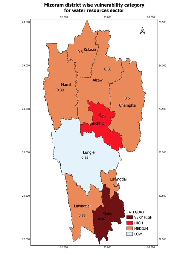
District Level Inherent Vulnerability of Mizoram to Climate Change in Water Resources Sector was done to rank and categorised different districts of Mizoram based on their vulnerability indices and drivers of vulnerability were identified.
Approach/Methodology adopted
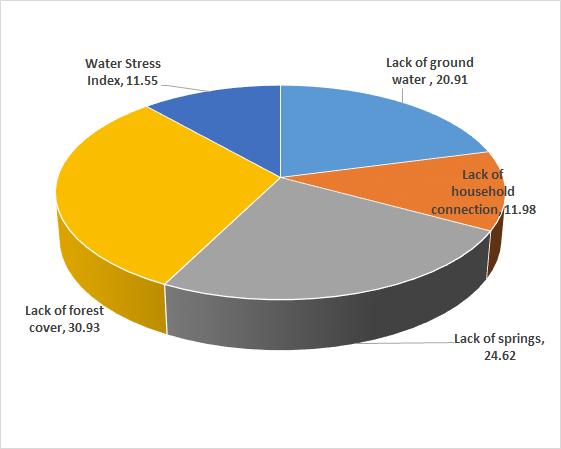
Top down assessment using secondary data collected from various sources and geospatial techniques were used. Secondary data were collected from Public Health Engineering Department, Government of Mizoram. The study was done by taking current vulnerability as a function of sensitivity and adaptive capacity. Five indicators belonging to a category water resources and demographic characteristics were selected for the assessment. Study was done unequal weights assigned to indicators. Unequal weights were assigned based on stakeholder and expert consultations. Districts were rank and categorized based on their calculated vulnerability indices. The selected five indicators used for the assessment are available ground water resources, percent household with piped water connection, No of springs per household, forest cover and water stress index.
Significant results brought out as a part of the project
District level vulnerability maps of Mizoram were generated for vulnerability ranking and vulnerability categories. The drivers of vulnerability were identified for the current scenario. The results of the assessment were yet to be compiled in a report booklet form. However, the result was presented in Young Scientists’ Conference, India International Science Festival 2019 at Kolkata during 5th to 7th November 2019.